جمهورية كومي
جمهورية كومي | |
|---|---|
| Республика Коми | |
| الترجمة اللفظية بالـ Other | |
| • كومي | Коми Республика |
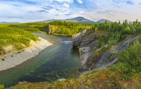 Kozhim river, Yugyd Va National Park | |
| النشيد: النشيد[1] | |
 | |
| الإحداثيات: 64°17′N 54°28′E / 64.283°N 54.467°E | |
| البلد | روسيا |
| المنطقة الاتحادية | الشمالية الغربية[2] |
| المنطقة الاقتصادية | الشمالي[3] |
| تأسست | December 5, 1936[4] |
| العاصمة | سيكتيڤكار[5] |
| الحكومة | |
| • الكيان | مجلس الدولة[6] |
| • الرئيس[6] | ڤيچسلاڤ گايزر[7] |
| المساحة | |
| • Total | 415٬900 كم² (160٬600 ميل²) |
| ترتيب المساحة | 13 |
| التعداد (2010 Census)[9] | |
| • Total | 901٬189 |
| • Estimate (2018) | 840٬873 (−6٫7%) |
| • الترتيب | 58 |
| • الكثافة | 2٫2/km2 (5٫6/sq mi) |
| • Urban | 76٫9% |
| • الريف | 23٫1% |
| منطقة التوقيت | UTC+3 (ت ع م+03:00 |
| ISO 3166 code | RU-KO |
| لوحات السيارات | 11 |
| OKTMO ID | 87000000 |
| اللغات الرسمية | الروسية;[11] الكومي[12] |
| الموقع الإلكتروني | http://www.rkomi.ru/en/ |
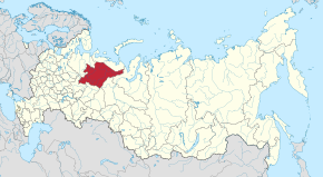
جمهورية كومي ([Респу́блика Ко́ми, Respublika Komi] Error: {{Lang-xx}}: text has italic markup (help); بالكومي: [Коми Республика, Komi Respublika] Error: {{Lang}}: text has italic markup (help)، Komi Republic)، هي كيان فدرالي روسي (جمهورية). عاصمتها مدينة سيكتيڤكار. عدد سكانها 901.189 نسمة (تعداد 2010).[9]
The population of the republic at the 2021 census was 737,853,[13] down from 901,189 at the 2010 census.[9]
التاريخ
The Komi people first feature in the records of the Novgorod Republic in the 11th century, when traders from Novgorod traveled to the Perm region in search of furs and animal hides. The Novgorodians called these lands Zavolochye ("beyond the portage"), from the Russian word volok ("portage"), and the Komi were referred to as "the Chud beyond the portage".[14] The Novgorodians penetrated deep into these lands, and the methods used were typical of those used by later Russians in subsequent campaigns.[14]
The Moscow principality also played an increasing role in the expansion into Komi territories, accompanied by a great increase in monastic activity in the 14th and 15th centuries under the influence of the Russian Orthodox Church.[14] The missionary Stephen of Perm, a native of Ustyug, created the first alphabet for the Komi, known by contemporary Russians as Zyrians (zyriane).[14] He settled in Ust-Vym and became the first bishop of Perm.[14] After Novgorod was annexed by Moscow, the Komi territories came under the influence of Moscow in the late 15th and early 16th century. The site of Syktyvkar, settled from the 16th century, was known as Sysolskoye (Сысольскoe). In 1780, under Catherine the Great, it was renamed to Ust-Sysolsk (Усть-Сысольск) and used as a penal colony.
Russians explored the Komi territory most extensively in the 19th and early 20th centuries, starting with the expedition led by Alexander von Keyserling in 1843. They found ample reservoirs of various minerals, as well as timber, to exploit. After the founding of the Soviet Union in 1922, the Komi-Zyryan Autonomous Oblast was established on August 22, 1921,[15] and on December 5, 1936, it was reorganized into the Komi Autonomous Soviet Socialist Republic with its administrative center located at the town of Syktyvkar.
Many of the "settlers" who arrived in the early 20th century were prisoners of the Gulag – sent by the hundreds of thousands to perform forced labor in the Arctic regions of the USSR. Towns sprang up around labor-camp sites, which gangs of prisoners initially carved out of the untouched tundra and taiga. The first mine, "Rudnik No. 1", became the city of Vorkuta, and other towns of the region have similar origins: "Prisoners planned and built all of the republic's major cities, not just Ukhta but also Syktyvkar, Pechora, Vorkuta, and Inta. Prisoners built Komi's railways and roads, as well as its original industrial infrastructure."[16] On 21 March 1996, the Komi Republic signed a power-sharing agreement with the government of Russia, granting it autonomy.[17] The agreement was abolished on 20 May 2002.[18]
الجغرافيا
تقع الجمهورية غرب جبال الأورال، شمال شرق السهل الأوروپي الشرقي. تغطي الغابات أكثر من 705 من أراضيها وتغطي المستنقعات ما يقارب 15%. The Komi Republic is the second-largest federal region by area in European Russia after Arkhangelsk Oblast.
- Area: 415،900 متر كيلومربع (160،600 sq mi)
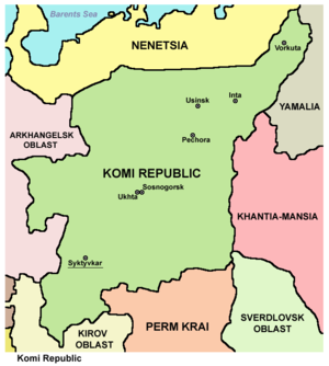
- Borders (all internal): Nenets (NW/N), Yamalo-Nenets (NE/E), Khanty–Mansi (E), Sverdlovsk (SE), Perm Krai (S), Kirov (S/SW), and Arkhangelsk (W).
- Highest point: Mount Narodnaya (1,894 m)
- Maximum N→S distance: 785 كيلومتر (488 mi)
- Maximum E→W distance: 695 كيلومتر (432 mi)
الأنهار
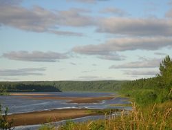
الأنهار الرئيسية في الجمهورية:
البحيرات الرئيسية
هناك الكثير من البحيرات في الجمهورية، والبحيرات الرئيسية تشمل:
الموارد الطبيعية
الموارد الطبيعية بالجمهورية تشمل الفحم، النفط، الغاز الطبيعي، الذهب، الماس والأخشاب.
المناخ
تتمتع الجمهورية بشتاء طويل وبارد وصيف قصير دافيء.
متوسط درجات الحرارة في يناير: −17 °C (1 °F) (المناطق الجنوبية) إلى −20 °C (−4 °F) (المناطق الشمالية)
- متوسط درجات الحرارة في يوليو: 11 °C (52 °F) (المناطق الشمالية) إلى 15 °C (59 °F) (المناطق الجنوبية)
- أقل درجات الحرارة: −58.1 °C (−72.6 °F) (قرية اوست-شچوگر)
- الهطول السنوي للأمطار: 625 mm (24.6 in)
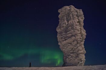
تكوينات مانپوپونر الصخرية
التقسيمات الادارية
التاريخ
الديموغرافيا
السكان
السكان: 901,189 (تعداد 2010);[9] 1,018,674 (تعداد 2002);[19] 1,261,024 (تعداد 1989).[20]
| 17-12-1926 | 17-01-1939 | 17-01-1959 | 15-01-1970 | 17-01-1979 | 17-01-1989 | 09-10-2002 | 14-10-2010 | |
|---|---|---|---|---|---|---|---|---|
| إجمالي السكان | 207,314 | 318,996 | 806,199 | 964,802 | 1,110,361 | 1,250,847 | 1,018,674 | 901,189 |
| المتوسط السنوي للنمو السكاني | +1.7% | +1.6% | +1.3% | -1.6% | -1.5% | |||
| الذكور | 46% | 49% | 52% | 50% | 51% | 50% | 48% | |
| الإناث | 54% | 51% | 48% | 50% | 49% | 50% | 52% | |
| الإناث لكل 1000 ذكر | ||||||||
| نسبة الحضر | 4.4% | 9.1% | 59.4% | 61.9% | 70.8% | 75.5% | 75.3% | |
| الأرض (كم2) | 434,150 | 415,900 | 415,900 | 415,900 | 415,900 | 415,900 | 415,900 | 415,900 |
| الكثافة السكانية/كم2 | 0.5 | 0.8 | 1.9 | 2.3 | 2.7 | 3.0 | 2.4 | 2.2 |
احصائيات حيوية
- المصدر: خدمة الإحصاء الحكومية الروسية
| متوسط السكان (x 1000) | المواليد الأحياء | الوفيات | التغير الطبيعي | معدل المواليد (لكل 1000) | معدل الوفيات (لكل 1000) | التغير الطبيعي (لكل 1000) | معدل الخصوبة | |
|---|---|---|---|---|---|---|---|---|
| 1920 | 4 760 | 4 353 | 407 | |||||
| 1930 | 10 256 | 6 574 | 3 682 | |||||
| 1940 | 14 976 | 12 134 | 2 842 | |||||
| 1945 | 6 432 | 6 185 | 247 | |||||
| 1950 | 534 | 20 087 | 6 002 | 14 085 | 37.6 | 11.2 | 26.4 | |
| 1960 | 836 | 25 578 | 5 010 | 20 568 | 30.6 | 6.0 | 24.6 | |
| 1965 | 938 | 18 956 | 5 241 | 13 715 | 20.2 | 5.6 | 14.6 | |
| 1970 | 970 | 16 462 | 6 276 | 10 186 | 17.0 | 6.5 | 10.5 | |
| 1975 | 1 044 | 18 899 | 7 284 | 11 615 | 18.1 | 7.0 | 11.1 | |
| 1980 | 1 137 | 20 685 | 9 169 | 11 516 | 18.2 | 8.1 | 10.1 | |
| 1981 | 1 153 | 21 244 | 9 103 | 12 141 | 18.4 | 7.9 | 10.5 | |
| 1982 | 1 169 | 23 420 | 8 758 | 14 662 | 20.0 | 7.5 | 12.5 | |
| 1983 | 1 185 | 23 806 | 9 250 | 14 556 | 20.1 | 7.8 | 12.3 | |
| 1984 | 1 199 | 24 217 | 9 486 | 14 731 | 20.2 | 7.9 | 12.3 | |
| 1985 | 1 213 | 23 303 | 9 334 | 13 969 | 19.2 | 7.7 | 11.5 | |
| 1986 | 1 228 | 24 176 | 8 112 | 16 064 | 19.7 | 6.6 | 13.1 | |
| 1987 | 1 242 | 23 616 | 8 544 | 15 072 | 19.0 | 6.9 | 12.1 | |
| 1988 | 1 256 | 20 916 | 8 930 | 11 986 | 16.7 | 7.1 | 9.5 | |
| 1989 | 1 256 | 18 481 | 8 857 | 9 624 | 14.7 | 7.1 | 7.7 | |
| 1990 | 1 244 | 16 930 | 9 321 | 7 609 | 13.6 | 7.5 | 6.1 | 1.873 |
| 1991 | 1 231 | 15 589 | 9 665 | 5 924 | 12.7 | 7.9 | 4.8 | |
| 1992 | 1 214 | 13 880 | 11 426 | 2 454 | 11.4 | 9.4 | 2.0 | |
| 1993 | 1 199 | 12 158 | 14 642 | - 2 484 | 10.1 | 12.2 | - 2.1 | |
| 1994 | 1 174 | 11 835 | 16 074 | - 4 239 | 10.1 | 13.7 | - 3.6 | |
| 1995 | 1 145 | 11 105 | 15 057 | - 3 952 | 9.7 | 13.2 | - 3.5 | 1.317 |
| 1996 | 1 124 | 10 900 | 13 674 | - 2 774 | 9.7 | 12.2 | - 2.5 | |
| 1997 | 1 106 | 10 388 | 12 244 | - 1 856 | 9.4 | 11.1 | - 1.7 | |
| 1998 | 1 087 | 10 793 | 11 545 | - 752 | 9.9 | 10.6 | - 0.7 | |
| 1999 | 1 068 | 9 680 | 12 253 | - 2 573 | 9.1 | 11.5 | - 2.4 | |
| 2000 | 1 050 | 9 906 | 13 594 | - 3 688 | 9.4 | 12.9 | - 3.5 | 1.219 |
| 2001 | 1 036 | 10 325 | 13 968 | - 3 643 | 10.0 | 13.5 | - 3.5 | 1.272 |
| 2002 | 1 021 | 11 177 | 15 265 | - 4 088 | 10.9 | 15.0 | - 4.0 | 1.374 |
| 2003 | 1 004 | 11 462 | 15 810 | - 4 348 | 11.4 | 15.8 | - 4.3 | 1.401 |
| 2004 | 987 | 11 489 | 15 210 | - 3 721 | 11.6 | 15.4 | - 3.8 | 1.397 |
| 2005 | 971 | 10 975 | 15 074 | - 4 099 | 11.3 | 15.5 | - 4.2 | 1.332 |
| 2006 | 955 | 10 872 | 13 519 | - 2 647 | 11.4 | 14.1 | - 2.8 | 1.318 |
| 2007 | 941 | 11 523 | 12 304 | - 781 | 12.2 | 13.1 | - 0.8 | 1.406 |
| 2008 | 928 | 11 719 | 12 270 | - 551 | 12.6 | 13.2 | - 0.6 | 1.452 |
| 2009 | 916 | 11 868 | 12 182 | - 314 | 13.0 | 13.3 | - 0.3 | 1.62 |
| 2010 | 903 | 11 648 | 11 819 | - 171 | 12.9 | 13.1 | - 0.2 | 1.63 |
| 2011 | 11 715 | 11 097 | + 443 | 13.0 | 12.4 | + 0.6 | 1.71 | |
| 2012 | 890 | 12 418 | 10 830 | + 1 588 | 14.0 | 12.2 | + 1.8 | 1.88 |
| 2013 | 876 | 12 436 | 10 484 | + 1 952 | 14.2 | 12.0 | + 2.2 | 1.96 |
| 2014 | 868 | 12 319 | 10 636 | + 1 683 | 14.1 | 12.2 | + 1.9 | 2.01(e) |
احصائيات حيوية اقليمية 2011
المصدر:[21]
| الكيان | معدلل المواليد | معدل الوفيات | معدل النمو الطبيعي | البيض % من السكان | الكومي والنانتس الأصليون % من السكان |
|---|---|---|---|---|---|
| جمهورية كومي | 13.0 | 12.4 | ▲0.06% | 96.05% | 3.95% |
| سيكتيڤكار | 12.5 | 10.2 | ▲0.23% | 97.61% | 2.39% |
| ڤوركوتا | 11.8 | 9.7 | ▲0.21% | 92.33% | 7.67% |
| ڤوكتيل | 11.2 | 12.6 | 95.27% | 4.73% | |
| إنتا | 11.1 | 12.6 | 95.40% | 4.60% | |
| پچورا | 13.0 | 13.6 | 96.89% | 3.11% | |
| سوسنوگورسك | 12.6 | 14.4 | 97.02% | 2.98% | |
| أوسينسك | 14.7 | 9.0 | ▲0.57% | 86.04% | 13.96% |
| أوختا | 11.0 | 10.7 | ▲0.03% | 96.20% | 3.80% |
| إژمسكي | 19.1 | 18.8 | ▲0.03% | 99.62% | 0.38% |
| كنياژوپوگوستسكي | 11.6 | 15.9 | 95.50% | 4.50% | |
| كويگورودسكي | 16.2 | 18.3 | 97.89% | 2.11% | |
| كورتكروسكي | 16.9 | 18.6 | 98.86% | 1.14% | |
| پريلوزسكي | 15.6 | 18.4 | 98.98% | 1.02% | |
| سيكتيڤدينسكي | 17.3 | 13.3 | ▲0.40% | 98.11% | 1.89% |
| سيسولسكي | 16.4 | 17.6 | 98.37% | 1.63% | |
| ترويتسكو-پچورسكي | 14.0 | 17.9 | 97.80% | 2.20% | |
| أودورسكي | 15.6 | 13.1 | ▲0.25% | 95.33% | 4.67% |
| أوست-ڤيمسكي | 12.0 | 15.8 | 96.48% | 3.52% | |
| أوست-كولومسكي | 19.2 | 18.9 | ▲0.03% | 98.96% | 1.04% |
| وست-تسيلمسكي | 16.1 | 15.4 | ▲0.07% | 99.62% | 0.38% |
الجماعات العرقية
| الجماعة العرقية |
تعداد 1926 (أراضي 1926)1 |
تعداد 1926 (الأراضي الحالية) |
تعداد 1939 | تعداد 1959 | تعداد 1970 | تعداد 1979 | تعداد 1989 | تعداد 2002 | تعداد 2010 2 | |||||||||
|---|---|---|---|---|---|---|---|---|---|---|---|---|---|---|---|---|---|---|
| العدد | % | العدد | % | العدد | % | العدد | % | العدد | % | العدد | % | العدد | % | العدد | % | العدد | % | |
| الكومي | 191,245 | 92.2% | 195,400 | 86.9% | 231,301 | 72.5% | 245,074 | 30.4% | 276,178 | 28.6% | 280,798 | 25.3% | 291,542 | 23.3% | 256,464 | 25.2% | 202,348 | 23.7% |
| الروس | 13,731 | 6.6% | 28,300 | 12.6% | 70,226 | 22.0% | 389,995 | 48.4% | 512,203 | 53.1% | 629,523 | 56.7% | 721,780 | 57.7% | 607,021 | 59.6% | 555,963 | 65.1% |
| الأوكرانيون | 34 | 0.0% | 200 | 0.1% | 6,010 | 1.9% | 80,132 | 9.9% | 82,955 | 8.6% | 94,154 | 8.5% | 104,170 | 8.3% | 62,115 | 6.1% | 36,082 | 4.2% |
| الننتس | 2,080 | 1.0% | 1,000 | 0.4% | 508 | 0.2% | 374 | 0.0% | 369 | 0.0% | 366 | 0.0% | 376 | 0.0% | 708 | 0.1% | ||
| التتار | 33 | 0.0% | 709 | 0.2% | 8,459 | 1.0% | 11,906 | 1.2% | 17,836 | 1.6% | 25,980 | 2.1% | 15,680 | 1.5% | 10,779 | 1.3% | ||
| البلاروس | 11 | 0.0% | 3,323 | 1.0% | 22,339 | 2.8% | 24,706 | 2.6% | 24,763 | 2.2% | 26,730 | 2.1% | 15,212 | 1.5% | 8,859 | 1.0% | ||
| آخرون | 180 | 0.1% | 6,919 | 2.2% | 59,826 | 7.4% | 56,485 | 5.9% | 62,921 | 5.7% | 80,269 | 6.4% | 61,474 | 6.0% | 40,272 | 4.7% | ||
| 1 The territory of the Komi AO was different from the Komi Republic.
2 Excluding 46,886 people who were registered from administrative databases, and could not declare an ethnicity. It is estimated that the proportion of ethnicities in this group is the same as that of the declared group.[22] | ||||||||||||||||||
الدين
السياسة
الاقتصاد
النقل
التعليم
الرياضة
انظر أيضاً
المصادر
الهوامش
- ^ Law #XII-20/5
- ^ Президент Российской Федерации. Указ №849 от 13 мая 2000 г. «О полномочном представителе Президента Российской Федерации в федеральном округе». (President of the Russian Federation. Decree #849 of May 13, 2000 On the Plenipotentiary Representative of the President of the Russian Federation in a Federal District).
- ^ Госстандарт Российской Федерации. №ОК 024-95 27 декабря 1995 г. «Общероссийский классификатор экономических регионов. 2. Экономические районы», в ред. Изменения №5/2001 ОКЭР. (گوستاندارت of the Russian Federation. #OK 024-95 December 27, 1995 Russian Classification of Economic Regions. 2. Economic Regions, as amended by the Amendment #5/2001 OKER).
- ^ Komi ASSR. Administrative-Territorial Structure, p. 5
- ^ Constitution of the Komi Republic, Article 69
- ^ أ ب Constitution, Article 8
- ^ Official website of the Komi Republic. Vyacheslav Gayzer (بالروسية)
- ^ Федеральная служба государственной статистики (Federal State Statistics Service) (2004-05-21). "Территория, число районов, населённых пунктов и сельских администраций по субъектам Российской Федерации (Territory, Number of Districts, Inhabited Localities, and Rural Administration by Federal Subjects of the Russian Federation)". Всероссийская перепись населения 2002 года (All-Russia Population Census of 2002) (in الروسية). Federal State Statistics Service. Retrieved 2011-11-01.
- ^ أ ب ت ث Russian Federal State Statistics Service (2011). "Всероссийская перепись населения 2010 года. Том 1". Всероссийская перепись населения 2010 года (2010 All-Russia Population Census) (in Russian). Federal State Statistics Service. Retrieved June 29, 2012.
{{cite web}}: Invalid|ref=harv(help); Unknown parameter|trans_title=ignored (|trans-title=suggested) (help)CS1 maint: unrecognized language (link) - ^ "Об исчислении времени". Официальный интернет-портал правовой информации (in الروسية). 3 June 2011. Retrieved 19 January 2019.
- ^ الرسمية في جميع أرجاء روسيا الاتحادية حسب الفقرة 68.1 من دستور روسيا.
- ^ Constitution of the Komi Republic, Article 67
- ^ "Оценка численности постоянного населения по субъектам Российской Федерации". Federal State Statistics Service. Retrieved 1 September 2022.
- ^ أ ب ت ث ج Forsyth, James (8 September 1994). A History of the Peoples of Siberia: Russia's North Asian Colony 1581-1990 (in الإنجليزية). Cambridge University Press. pp. 2–5. ISBN 978-0-521-47771-0.
- ^ Коми Автономная Советская Социалистическая Республика. Great Soviet Encyclopedia. Retrieved 22 June 2020.
- ^ Anne Applebaum, Gulag: A History (Random House, Inc., 2004: ISBN 1-4000-3409-4), pp. 78, 82.
- ^ "Russia Signs Power-Sharing Treaty with Komi Republic". Jamestown (in الإنجليزية الأمريكية). 1996-03-21. Retrieved 2019-05-02.
- ^ Chuman, Mizuki. "The Rise and Fall of Power-Sharing Treaties Between Center and Regions in Post-Soviet Russia" (PDF). Demokratizatsiya: 146. Archived from the original (PDF) on March 8, 2019. Retrieved May 2, 2019.
- ^ Федеральная служба государственной статистики (Federal State Statistics Service) (2004-05-21). "Численность населения России, субъектов Российской Федерации в составе федеральных округов, районов, городских поселений, сельских населённых пунктов – районных центров и сельских населённых пунктов с населением 3 тысячи и более человек[[Category:Articles containing روسية-language text]] (Population of Russia, its federal districts, federal subjects, districts, urban localities, rural localities—administrative centers, and rural localities with population of over 3,000)". Всероссийская перепись населения 2002 года (All-Russia Population Census of 2002) (in Russian). Federal State Statistics Service. Retrieved 2008-07-25.
{{cite web}}: URL–wikilink conflict (help)CS1 maint: unrecognized language (link) - ^ "Всесоюзная перепись населения 1989 г. Численность наличного населения союзных и автономных республик, автономных областей и округов, краёв, областей, районов, городских поселений и сёл-райцентров.[[Category:Articles containing روسية-language text]] (All Union Population Census of 1989. Present population of union and autonomous republics, autonomous oblasts and okrugs, krais, oblasts, districts, urban settlements, and villages serving as district administrative centers.)". Всесоюзная перепись населения 1989 года (All-Union Population Census of 1989) (in Russian). Demoscope Weekly (website of the Institute of Demographics of the State University—Higher School of Economics. 1989. Retrieved 2007-12-13.
{{cite web}}: Italic or bold markup not allowed in:|publisher=(help); URL–wikilink conflict (help)CS1 maint: unrecognized language (link) - ^ http://www.gks.ru/dbscripts/munst/munst87/DBInet.cgi
- ^ http://www.perepis-2010.ru/news/detail.php?ID=6936
- ^ Arena - Atlas of Religions and Nationalities in Russia. Sreda.org
- ^ 2012 Survey Maps. "Ogonek", № 34 (5243), 27/08/2012. Retrieved 24-09-2012.
المراجع
- قالب:RussiaBasicLawRef/ko
- Государственный Совет Республики Коми. Закон №XII-20/5 от 6 июня 1994 г. «О государственном гимне Республики Коми», в ред. Закона №44-РЗ от 4 июля 2006 г «О внесении изменений и дополнения в Закон Республики Коми "О Государственном гимне Республики Коми"». (State Council of the Komi Republic. Law #XII-20/5 of June 6, 1994 On the State Anthem of the Komi Republic, as amended by the Law #44-RZ of July 4, 2006 On Amending and Supplementing the Law of the Komi Republic "On the State Anthem of the Komi Republic").
- "Коми АССР. Административно-территориальное деление на 1 июля 1968 г." Коми книжное издательство. Сыктывкар, 1968. (Komi ASSR. Administrative-Territorial Structure as of July 1, 1968)
قراءات إضافية
- Pearson, M., Ojanen, P., Havimo, M., Kuuluvainen, T. & Vasander, H. (eds.) 2007. On the European Edge — Journey through Komi Nature and Culture. University of Helsinki Department of Forest Ecology Publications 36. 216 p. ISBN 978-952-10-3898-3.
- Strogoff, M., Brochet, P. & Auzias, D. 2005. Guidebook Komi Republic. Avant-Garde Publishers, Moscow. 176. p. ISBN 5-86394-255-X.
وصلات خارجية
- (بالروسية) الموقع الرسمي لجمهورية كومي
- (بالروسية) جميع أخبار جمهورية كومي
- (بالروسية) Website of Syktyvkar City - The Capital of the Republic of Komi
- (بالروسية) Official website of the Vorkuta City
- Official site of the Syktyvkar State University)
- (بالروسية) Official site of the Syktyvkar State University)
- (بالروسية) Official site of the Ukhta State Technical University
- (بالروسية) Snowboarding in Komi Republic
- (بالروسية) History Komi
- Map of the Komi Republic
- Historic-demographic note on the Nenets of the Komi Republic
- Virgin Komi Forests at Natural Heritage Protection Fund
- Pages using gadget WikiMiniAtlas
- Articles containing روسية-language text
- CS1 الروسية-language sources (ru)
- CS1 errors: unsupported parameter
- CS1 الإنجليزية الأمريكية-language sources (en-us)
- CS1 errors: URL–wikilink conflict
- CS1 errors: markup
- Short description matches Wikidata
- Short description is different from Wikidata
- Coordinates on Wikidata
- Lang and lang-xx template errors
- Pages using Lang-xx templates
- Articles with hatnote templates targeting a nonexistent page
- Pages using div col with unknown parameters
- جمهورية كومي
- جمهوريات روسيا
- دول وأراضي تأسست في 1936
- أعضاء منظمة الأمم والشعوب غير الممثلة


