ماستريخت
(تم التحويل من ماستريشت)
Maastricht
Mestreech | |
|---|---|
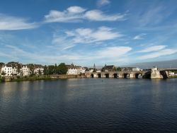 View of Maastricht city centre with its partly medieval bridge on the Meuse river | |
| النشيد: Mestreechs Volksleed | |
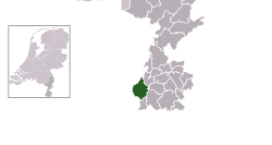 Location in Limburg | |
| الإحداثيات: 50°51′N 5°41′E / 50.850°N 5.683°E | |
| Country | Netherlands |
| Province | Limburg |
| Settled | ≈ 500 BC |
| City rights | 1204 |
| الأحياء | 7 Districts
|
| الحكومة | |
| • الكيان | Municipal council |
| • Mayor | Annemarie Penn-te Strake |
| المساحة | |
| • Municipality | 60٫03 كم² (23٫18 ميل²) |
| • البر | 56٫81 كم² (21٫93 ميل²) |
| • الماء | 3٫22 كم² (1٫24 ميل²) |
| المنسوب | 49 m (161 ft) |
| التعداد | |
| • Municipality | 121٬501 |
| • الكثافة | 2٬139/km2 (5٬540/sq mi) |
| • Urban | 121٬906 |
| • العمرانية | 182٬721 |
| Urban and metro population for Dutch area only, thus excluding Belgian environs[6] | |
| صفة المواطن | (Dutch) Maastrichtenaar; (Limb.) Mestreechteneer or Sjeng |
| منطقة التوقيت | UTC+1 (CET) |
| • الصيف (التوقيت الصيفي) | UTC+2 (CEST) |
| Postcode | 6200–6229 |
| Area code | 043 |
| الموقع الإلكتروني | www |
ماستريخت (Maastricht ؛ هولندية: [maːˈstrɪxt] (![]() استمع);[7] Limburgish (incl. Maastrichtian): Mestreech []; French: Maestricht (archaic); Spanish: Mastrique (archaic)) is a town and a municipality in the southeast of the Netherlands. It is the capital city in the province of Limburg.
استمع);[7] Limburgish (incl. Maastrichtian): Mestreech []; French: Maestricht (archaic); Spanish: Mastrique (archaic)) is a town and a municipality in the southeast of the Netherlands. It is the capital city in the province of Limburg.
تقع ماستريخت على ضفتي نهر موز (بالهولندية: Maas)، عند النقطة التي يلتقي رافده نهر يكر (بالفرنسية: Geer) .
التاريخ
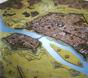
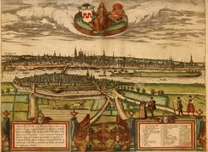
ماكيت ماستريخت في 1750
المناخ
| بيانات المناخ لـ Maastricht | |||||||||||||
|---|---|---|---|---|---|---|---|---|---|---|---|---|---|
| الشهر | ينا | فب | مار | أبر | ماي | يون | يول | أغس | سبت | أكت | نوف | ديس | السنة |
| القصوى القياسية °س (°ف) | 15.5 (59.9) |
19.1 (66.4) |
22.2 (72.0) |
26.7 (80.1) |
30.6 (87.1) |
34.0 (93.2) |
35.9 (96.6) |
36.2 (97.2) |
31.3 (88.3) |
26.6 (79.9) |
21.1 (70.0) |
16.4 (61.5) |
36.2 (97.2) |
| متوسط القصوى اليومية °س (°ف) | 5.2 (41.4) |
6.1 (43.0) |
10.1 (50.2) |
14.0 (57.2) |
18.3 (64.9) |
20.9 (69.6) |
23.3 (73.9) |
23.0 (73.4) |
19.1 (66.4) |
14.7 (58.5) |
9.2 (48.6) |
5.8 (42.4) |
14.1 (57.4) |
| المتوسط اليومي °س (°ف) | 2.7 (36.9) |
3.1 (37.6) |
6.3 (43.3) |
9.3 (48.7) |
13.5 (56.3) |
16.2 (61.2) |
18.4 (65.1) |
18.0 (64.4) |
14.7 (58.5) |
10.9 (51.6) |
6.4 (43.5) |
3.5 (38.3) |
10.2 (50.4) |
| متوسط الدنيا اليومية °س (°ف) | 0.0 (32.0) |
0.0 (32.0) |
2.6 (36.7) |
4.7 (40.5) |
8.5 (47.3) |
11.3 (52.3) |
13.5 (56.3) |
13.2 (55.8) |
10.5 (50.9) |
7.2 (45.0) |
3.5 (38.3) |
0.9 (33.6) |
6.3 (43.3) |
| الصغرى القياسية °س (°ف) | −19.3 (−2.7) |
−14.7 (5.5) |
−12.9 (8.8) |
−4.9 (23.2) |
−0.8 (30.6) |
0.9 (33.6) |
5.2 (41.4) |
5.5 (41.9) |
1.6 (34.9) |
−4.2 (24.4) |
−9.0 (15.8) |
−15.4 (4.3) |
−19.3 (−2.7) |
| متوسط تساقط الأمطار mm (inches) | 65.3 (2.57) |
57.4 (2.26) |
61.8 (2.43) |
45.1 (1.78) |
65.9 (2.59) |
70.5 (2.78) |
69.6 (2.74) |
72.3 (2.85) |
61.6 (2.43) |
67.2 (2.65) |
65.3 (2.57) |
70.8 (2.79) |
772.8 (30.44) |
| Average precipitation days (≥ 1 mm) | 12 | 10 | 12 | 9 | 10 | 10 | 10 | 10 | 9 | 10 | 12 | 12 | 126 |
| متوسط الرطوبة النسبية (%) | 87 | 84 | 80 | 74 | 73 | 75 | 75 | 76 | 82 | 85 | 89 | 89 | 81 |
| Mean monthly ساعات سطوع الشمس | 59.9 | 79.3 | 119.3 | 164.0 | 194.9 | 188.9 | 202.8 | 187.3 | 140.0 | 113.6 | 65.9 | 44.9 | 1٬560٫8 |
| Source 1: Royal Netherlands Meteorological Institute (1981–2010 normals, snowy days normals for 1971–2000)[8] | |||||||||||||
| Source 2: Royal Netherlands Meteorological Institute (1971–2000 extremes)[9] | |||||||||||||
السكان
Total population
|
Inhabitants by nationality
| Maastricht residents by nationality - Top 10 (1 January 2014)[13] | |||
|---|---|---|---|
| Nationality | 2014 | 2010 | 2000 |
| 107,418 | 109,722 | 116,171 | |
| 3,869 | 1,956 | 783 | |
| 1,055 | 946 | 909 | |
| 815 | 386 | 280 | |
| 653 | 387 | 280 | |
| 623 | 277 | 162 | |
| 595 | 248 | 87 | |
| 431 | 232 | 241 | |
| 404 | 368 | 404 | |
| 351 | 214 | 120 | |
Inhabitants by country of birth
| Maastricht residents by country of birth - Top 10 (1 January 2013)[14] | |||
|---|---|---|---|
| Country of birth | 2013 | 2010 | 2000 |
| 100,269 | 102,433 | 109,632 | |
| 4,100 | 2,467 | 1,444 | |
| 1,920 | 1,839 | 1,900 | |
| 1,199 | 1,267 | 1,556 | |
| 919 | 836 | 784 | |
| 838 | 867 | 859 | |
| Former Soviet Union | 842 | 564 | 183 |
| 753 | 383 | 217 | |
| 677 | 404 | 310 | |
| 651 | 373 | 215 | |
المسافات للمدن الأخرى
These distances are as the crow flies and therefore not represent actual overland distances.
 Liège: 25.5 km (15.8 mi) south
 Aachen: 31.0 km (19.3 mi) east
 Düsseldorf: 86.2 km (53.6 mi) north-east
 Cologne: 89.6 km (55.7 mi) east
 Brussels: 95.1 km (59.1 mi) west
 Antwerp: 97.8 km (60.8 mi) north-west
 Bonn: 99.9 km (62.1 mi) south-east
 Luxembourg City: 141.4 km (87.9 mi) south
 Utrecht: 142.4 km (88.5 mi) north-west
 Rotterdam: 144.5 km (89.8 mi) north-west
 Amsterdam: 175.1 km (108.8 mi) north-west
 Lille: 186.3 km (115.8 mi) west
 Frankfurt am Main: 228.8 km (142.2 mi) south-east
 Leeuwarden: 261.6 km (162.6 mi) north
 Paris: 326.6 km (202.9 mi) south-west
 لندن: 411.5 km (255.7 mi) north-west
انظر أيضاً
الهامش
- ^ "Mrs. Annemarie Penn-te Strake" (in Dutch). Gemeente Maastricht. Retrieved 12 October 2013.
{{cite web}}: Unknown parameter|trans_title=ignored (|trans-title=suggested) (help)CS1 maint: unrecognized language (link) - ^ "Kerncijfers wijken en buurten" [Key figures for neighbourhoods]. CBS Statline (in Dutch). CBS. 2 July 2013. Retrieved 12 March 2014.
{{cite web}}: CS1 maint: unrecognized language (link) - ^ "Postcodetool for 6211DW". Actueel Hoogtebestand Nederland (in Dutch). Het Waterschapshuis. Retrieved 12 October 2013.
{{cite web}}: Cite has empty unknown parameter:|trans_title=(help)CS1 maint: unrecognized language (link) - ^ "Bevolkingsontwikkeling; regio per maand" [Population growth; regions per month]. CBS Statline (in Dutch). CBS. 27 October 2017. Retrieved 27 October 2017.
{{cite web}}: CS1 maint: unrecognized language (link) - ^ "Bevolkingsontwikkeling; regio per maand". CBS Statline (in Dutch). CBS. 26 June 2014. Retrieved 24 July 2014.
{{cite web}}: Unknown parameter|trans_title=ignored (|trans-title=suggested) (help)CS1 maint: unrecognized language (link) - ^ "Stadsgewesten en stedelijke agglomeraties Nederland 2011" (PDF). Centraal Bureau voor de Statistiek. 2011. Retrieved 2013-10-13.
- ^ Local pronunciation: []
- ^
"Klimaattabel Maastricht, langjarige gemiddelden, tijdvak 1981–2010" (PDF) (in Dutch). Royal Netherlands Meteorological Institute. Retrieved 10 September 2013.
{{cite web}}: CS1 maint: unrecognized language (link) - ^
"Klimaattabel Maastricht, langjarige extremen, tijdvak 1971–2000" (PDF) (in Dutch). Royal Netherlands Meteorological Institute. Retrieved 10 September 2013.
{{cite web}}: CS1 maint: unrecognized language (link) - ^ أ ب Jansen, J.C.G.M. (1986). "Maastricht tussen 1813 en 1850" (PDF). BMCN. 101 (4): 529–550. Retrieved February 10, 2012.
- ^ أ ب ت ث ج ح Centraal Bureau voor de Statistiek. "Bevolkingsontwikkeling; regio per jaar". Retrieved 17 December 2012.
- ^ Centraal Bureau voor de Statistiek. "Bevolkingsontwikkeling; regio per maand". Retrieved 12 April 2013.
- ^ "Bevolking; geslacht, leeftijd, nationaliteit en regio, 1 januari (in Dutch)". Bevolking; geslacht, leeftijd, nationaliteit en regio, 1 januari. Centraal Bureau voor de Statistiek. 2014: page 1. 24 October 2014. Retrieved 3 February 2015.
{{cite journal}}:|page=has extra text (help) - ^ "Bevolking op 1 januari; leeftijd, geboorteland en regio (in Dutch)". Bevolking op 1 januari; leeftijd, geboorteland en regio. Centraal Bureau voor de Statistiek. 201w: page 1. 17 July 2013. Retrieved 3 February 2015.
{{cite journal}}:|page=has extra text (help)
وصلات خارجية
| Find more about ماستريخت at Wikipedia's sister projects | |
| Media from Commons | |
| Travel guide from Wikivoyage | |
- Maastricht city portal
- Maastricht municipality website
- Maastricht in Roman times
- Webpage about Maastricht fortifications
- Webpage about the 1673 siege
الكلمات الدالة:
This article may include material from Wikimedia licensed under CC BY-SA 4.0. Please comply with the license terms.
تصنيفات:
- Pages using gadget WikiMiniAtlas
- CS1 errors: unsupported parameter
- CS1 errors: extra text: pages
- Short description is different from Wikidata
- Articles containing Limburgish-language text
- Coordinates on Wikidata
- صفحات تستخدم جدول مستوطنة بقائمة محتملة لصفات المواطن
- Pages using infobox settlement with unknown parameters
- ماستريخت
- مدن هولندا
- Municipalities of Limburg (Netherlands)
- Populated places in Limburg (Netherlands)
- Provincial capitals of the Netherlands
- University towns in the Netherlands
- Belgium–Netherlands border crossings


