مقاطعة في مزوري، الولايات المتحدة
Place
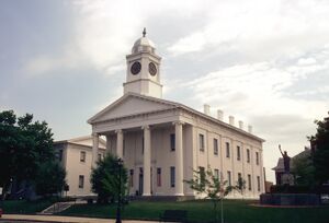
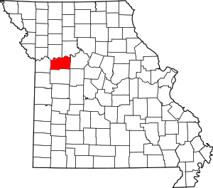
مقاطعة لافاييت إنگليزية: Lafayette County هي إحدى المقاطعات في ولاية ميزوري في الولايات المتحدة .
الجغرافيا According to the U.S. Census Bureau , the county has a total area of 639 ميل مربع (1،660 km2 ), of which 628 ميل مربع (1،630 km2 ) is land and 11 ميل مربع (28 km2 ) (1.6%) is water.[1]
المقاطعات المجاورة السياسة المحلية The Republican Party mostly controls politics at the local level in Lafayette County. Republicans hold a little more than half of the elected positions in the county.
قالب:Missouri county elected officials
الولاية
Past Gubernatorial Elections Results
Year
Republican
Democratic
Third Parties
2016
57.85% 9,167
38.47% 6,097
3.68% 583
2012
47.91% 7,537
49.31% 7,758
2.78% 438
2008
42.70% 7,022
55.09% 9,060
2.21% 364
2004
52.97% 8,541
45.59% 7,351
1.43% 231
2000
50.32% 7,276
47.94% 6,932
1.74% 251
1996
34.00% 4,450
63.05% 8,252
2.94% 385
Lafayette County is divided into two legislative districts in the Missouri House of Representatives , both of which are held by Republicans.
Missouri House of Representatives — District 33 — Lafayette County (2016)
الحزب
المرشح
الأصوات
%
±%
Republican
Donna Pfautsch
51
72.86%
-2.81
Democratic
Chase Linder
19
27.14%
+19.03
Missouri House of Representatives — District 33 — Lafayette County (2014)
الحزب
المرشح
الأصوات
%
±%
Republican
Donna Pfautsch
28
75.67%
+10.96
Democratic
Syed Asif
3
8.11%
-27.18
Libertarian
Matt Stephens
6
16.22%
+16.22
Missouri House of Representatives — District 33 — Lafayette County (2012)
الحزب
المرشح
الأصوات
%
±%
Republican
Donna Pfautsch
33
64.71%
Democratic
Ron Harvey
18
35.29%
Missouri House of Representatives — District 53 — Lafayette County (2016)
الحزب
المرشح
الأصوات
%
±%
Republican
Glen Kolkmeyer
13,719
100.00%
+38.93
Missouri House of Representatives — District 53 — Lafayette County (2014)
الحزب
المرشح
الأصوات
%
±%
Republican
Glen Kolkmeyer
5,818
61.07%
+2.43
Democratic
Henry Grubb
3,709
38.93%
-2.43
Missouri House of Representatives — District 53 — Lafayette County (2012)
الحزب
المرشح
الأصوات
%
±%
Republican
Glen Kolkmeyer
9,095
58.64%
Democratic
Holmes Osborne
6,416
41.36%
All of Lafayette County is a part of Missouri's 21st District in the Missouri Senate and is currently represented by Denny Hoskins (R-Warrensburg ).
Missouri Senate — District 21 — Lafayette County (2016)
الحزب
المرشح
الأصوات
%
±%
Republican
Denny Hoskins
9,738
63.36%
+1.36
Democratic
ElGene Ver Dught
4,864
31.65%
-2.80
Libertarian
Bill Wayne
768
5.00%
-1.45
Missouri Senate — District 21 — Lafayette County (2012)
الحزب
المرشح
الأصوات
%
±%
Republican
David Pearce
9,547
62.00%
Democratic
ElGene Ver Dught
5,305
34.45%
Libertarian
Steven Hedrick
547
3.55%
الفدرالية
U.S. Senate — Missouri — Lafayette County (2016)
الحزب
المرشح
الأصوات
%
±%
Republican
Roy Blunt
8,812
55.55%
+12.89
Democratic
Jason Kander
6,150
38.77%
-10.49
Libertarian
Jonathan Dine
436
2.75%
-5.33
Green
Johnathan McFarland
167
1.05%
+1.05
Constitution
Fred Ryman
299
1.88%
+1.88
U.S. Senate — Missouri — Lafayette County (2012)
الحزب
المرشح
الأصوات
%
±%
Republican
Todd Akin
6,663
42.66%
Democratic
Claire McCaskill
7,695
49.26%
Libertarian
Jonathan Dine
1,262
8.08%
All of Lafayette County is included in Missouri's 5th Congressional District , which is currently represented by Emanuel Cleaver (D-Kansas City ) in the U.S. House of Representatives .
U.S. House of Representatives — Missouri's 5th Congressional District — Lafayette County (2016)
الحزب
المرشح
الأصوات
%
±%
Democratic
Emanuel Cleaver II
5,744
36.50%
+3.58
Republican
Jacob Turk
9,505
60.39%
-3.58
Libertarian
Roy Welborn
490
3.11%
U.S. House of Representatives — Missouri's 5th Congressional District — Lafayette County (2014)
الحزب
المرشح
الأصوات
%
±%
Democratic
Emanuel Cleaver II
3,153
32.92%
-6.74
Republican
Jacob Turk
6,128
63.97%
+6.90
Libertarian
Roy Welborn
298
3.11%
-0.16
U.S. House of Representatives — Missouri’s 5th Congressional District — Lafayette County (2012)
الحزب
المرشح
الأصوات
%
±%
Democratic
Emanuel Cleaver II
6,202
39.66%
Republican
Jacob Turk
8,925
57.07%
Libertarian
Randy Langkraehr
511
3.27%
نتائج الانتخابات الرئاسية الأمريكية في Lafayette County, Missouri [2] [2]
السنة
الجمهوري
الديمقراطي
حزب ثالث
رقم.
%
رقم.
%
رقم.
%
2020 12,273
71٫79%
4,472
26٫16%
351
2٫05%
2016 10,988
68٫78%
4,053
25٫37%
934
5٫85%
2012 9,803
61٫79%
5,655
35٫64%
408
2٫57%
2008 9,442
56٫88%
6,902
41٫58%
256
1٫54%
2004 9,656
59٫67%
6,412
39٫62%
114
0٫70%
2000 7,849
54٫06%
6,343
43٫68%
328
2٫26%
1996 5,489
41٫57%
6,118
46٫34%
1,596
12٫09%
1992 4,651
34٫54%
5,213
38٫71%
3,603
26٫75%
1988 6,825
54٫54%
5,654
45٫18%
35
0٫28%
1984 8,581
63٫90%
4,848
36٫10%
0
0�00%
1980 7,271
53٫99%
5,792
43٫01%
405
3٫01%
1976 6,823
51٫28%
6,410
48٫18%
72
0٫54%
1972 9,187
69٫34%
4,063
30٫66%
0
0�00%
1968 6,840
53٫42%
4,859
37٫95%
1,105
8٫63%
1964 5,493
42٫60%
7,400
57٫40%
0
0�00%
1960 8,011
59٫05%
5,555
40٫95%
0
0�00%
1956 8,133
57٫22%
6,081
42٫78%
0
0�00%
1952 8,805
59٫26%
6,020
40٫52%
32
0٫22%
1948 6,634
52٫48%
5,988
47٫37%
20
0٫16%
1944 7,951
58٫63%
5,603
41٫32%
7
0٫05%
1940 8,802
55٫91%
6,913
43٫91%
29
0٫18%
1936 7,535
50٫70%
7,275
48٫95%
51
0٫34%
1932 5,670
41٫65%
7,906
58٫08%
37
0٫27%
1928 7,687
56٫28%
5,939
43٫48%
32
0٫23%
1924 6,517
50٫43%
5,877
45٫48%
529
4٫09%
1920 7,471
54٫40%
6,169
44٫92%
94
0٫68%
1916 4,049
49٫09%
4,073
49٫38%
126
1٫53%
1912 2,367
31٫73%
3,650
48٫93%
1,442
19٫33%
1908 3,771
48٫57%
3,865
49٫78%
128
1٫65%
1904 3,531
48٫82%
3,583
49٫54%
119
1٫65%
1900 3,311
43٫40%
4,217
55٫28%
101
1٫32%
1896 3,375
42٫72%
4,463
56٫49%
63
0٫80%
1892 2,833
40٫33%
3,922
55٫83%
270
3٫84%
1888 2,819
41٫27%
3,865
56٫59%
146
2٫14%
التجمعات المدن والبلدات Unincorporated communities انظر أيضاً المراجع وصلات خارجية
أماكن قريبة من مقاطعة لافاييت، ميزوري
قالب:Kansas City MSA
قالب:Lafayette County, Missouri


