مقاطعة مايسن
Meissen (Meißen) | |
|---|---|
 Flag  الدرع | |
 | |
| البلد | ألمانيا |
| الولاية | ساكسونيا |
| Capital | مايسن |
| الحكومة | |
| • District admin. | Ralf Hänsel (CDU) |
| المساحة | |
• الإجمالي | 1٬453 كم² (561 ميل²) |
| التعداد (31 ديسمبر 2024)[1] | |
• الإجمالي | 239٬221 |
| • الكثافة | 160/km2 (430/sq mi) |
| منطقة التوقيت | UTC+01:00 (CET) |
| • الصيف (التوقيت الصيفي) | UTC+02:00 (CEST) |
| لوحة السيارة | MEI, GRH, RG, RIE |
| الموقع الإلكتروني | www |
مايسن (Meissen ؛ ألمانية: Meißen) هي مقاطعة (Kreis) في ساكسونيا، ألمانيا. It is bounded by (from the north and clockwise) the state of Brandenburg, the district of Bautzen, the urban district Dresden, the districts Sächsische Schweiz-Osterzgebirge, Mittelsachsen and Nordsachsen.
التاريخ
The district dates back to the Amt Meißen, which was first mentioned in 1334. The district was ruled by the Wettin dynasty. The Margraves of what then became the Margravate of Meissen created the administrative division (Amt) in the 13th century. In 1835 the Amt was converted into an Amtshauptmannschaft, with the area of the current district covered by the Amtshauptmannschaften Meissen, Dresden and Großenhain. In 1939, these were renamed Landkreise (districts). In the administrative reform of 1952, several municipalities were transferred to the districts of Freiberg and Döbeln. In 1990, the old district borders were restored, and in 1996 parts of the district Dresden-Land were added. In August 2008 the district of Riesa-Großenhain was added to the district to give it its current size.
الجغرافيا
The main river of the district is the Elbe, which also flows through the town of Meissen.
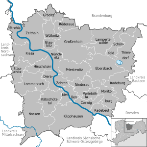
البلدات والبلديات
| البلدات | البلديات | |
|---|---|---|
السياسة
المراجع
- ^ "Bevölkerung der Gemeinden Sachsens am 31. Dezember 2024 – Fortschreibung des Bevölkerungsstandes auf Basis des Zensus vom 15. Mai 2022 (Gebietsstand 01.01.2024)" (in German). Statistisches Landesamt des Freistaates Sachsen.
{{cite web}}: CS1 maint: unrecognized language (link)
External links
 Media related to County of Meissen at Wikimedia Commons
- Official website (German)
- Unofficial website (German)
51°13′N 13°31′E / 51.217°N 13.517°E
مدن وبلديات مقاطعة مايسن | ||
|---|---|---|
| ||
 Urban and rural districts in Saxony, Germany Urban and rural districts in Saxony, Germany | |
|---|---|
| Urban districts | |
| Rural districts | |
| Former urban districts | |
| Former rural districts | |
| International | |
|---|---|
| National | |
